My questing buddy Tom Thrash and I both have a quest to cross all 107 state borders—the boundaries where two US states meet via a land or river crossing.
→ Check out #GoQuesting1006 for more information on this unusual travel quest ←
One of them is particularly sneaky—the tiny border shared by Kentucky and Missouri.
There are a number of border anomalies along the Mississippi River, as its course shifted after state boundaries were originally established. This has led some parts of states to suddenly find themselves disconnected from the rest of their state by the main channel of the river. The most famous cases of this are probably Carter Lake, Iowa and the "Kentucky Bend," a finger of Kentucky that is now only accessible by road from Tennessee:
In a similarly odd fate, there is no bridge over the Mississippi between the states of Kentucky and Missouri. US Highways 51 and 62 nearly connect the two states, but happen to meet in a sliver of Illinois, a painfully short distance upstream of the Ohio and Mississippi confluence and the northern start of the KY-MO border. Both highway bridges cross less than a mile from the tri-point. Coincidentally, not too far upstream on the Mississippi from this point lies a bit of Illinois that shares a similar fate as the Kentucky Bend—you can only drive there from Missouri.

Ok, so there's no bridge across the KY-MO border, but the small Dorena-Hickman Ferry does provide cross-boundary access. Many believe this is the only direct route between these two states. However, for the purposes of this quest, border crossings don't count if you're in a plane or on a boat.
So perhaps there are only 106 objectives in this quest instead of the original 107? Not so fast, my friend.
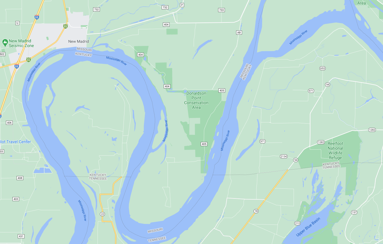
It turns out there is at least one road that does cross the KY-MO border. It's on what’s known as “Wolf Island Number 5,” and was part of a lawsuit between the two states that was decided by the US Supreme Court back way back in 1870 in a case called Missouri v Kentucky.
This island stood in the middle of the Mississippi River when the two state boundaries were formalized. Eventually, however, the river shifted its course eastward. And sometime after that, as the river flowed further east, the old river bend was partially filled in, connecting the island to the riverbank on the Missouri side. Wolf Island is now a peninsula, consisting primarily of some farming fields, sandy areas, and what appears to be a single outbuilding for farming equipment. The Supreme Court case held that Kentucky should maintain control of the area, even though the Mississippi River was intended to be the dividing line between the states. And so the state boundary remains where it was prior.
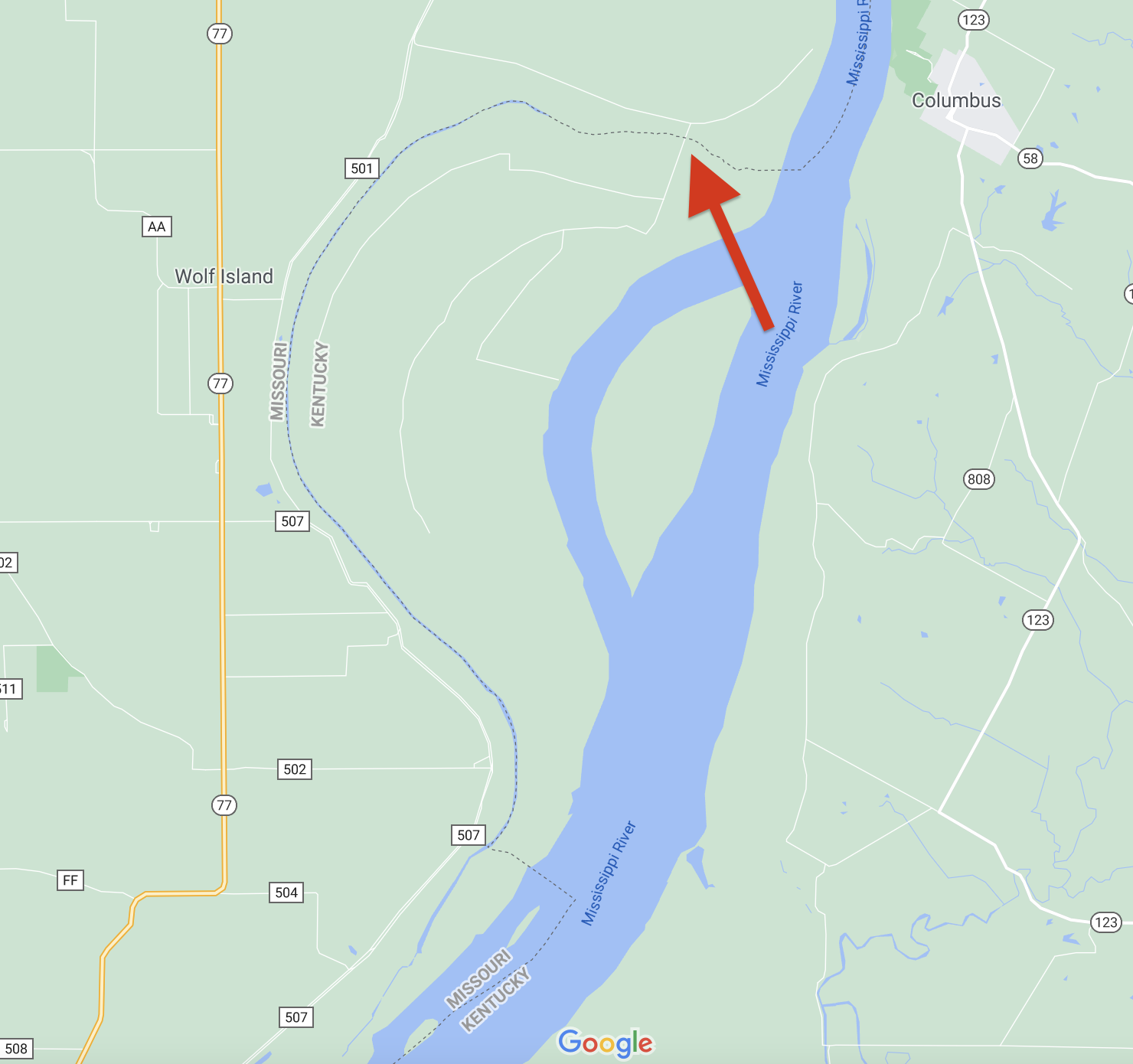
A county-maintained dirt road—Wolf Island Road—now unceremoniously crosses the boundary onto the peninsula. As far as I can tell, it's the only publicly accessible land crossing between the two states. The roadway is county-maintained and listed in the state's database and GIS maps. In short, it looks like a legit border crossing for the purposes of this quest.
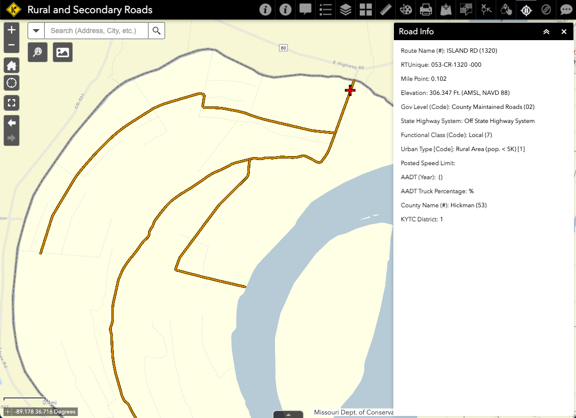
There is one additional roadway, according to Google Maps at least, that crosses the border a bit further upstream onto what is labeled "Island Nos 2 3 and 4." But the roadway is not shown on the Kentucky Transportation Cabinet's "Rural and Secondary Roads" or "Local Roads" GIS maps. Given this telling omission, plus a closed gate as seen on satellite imagery from Google Maps, leads me to believe it's a private route.
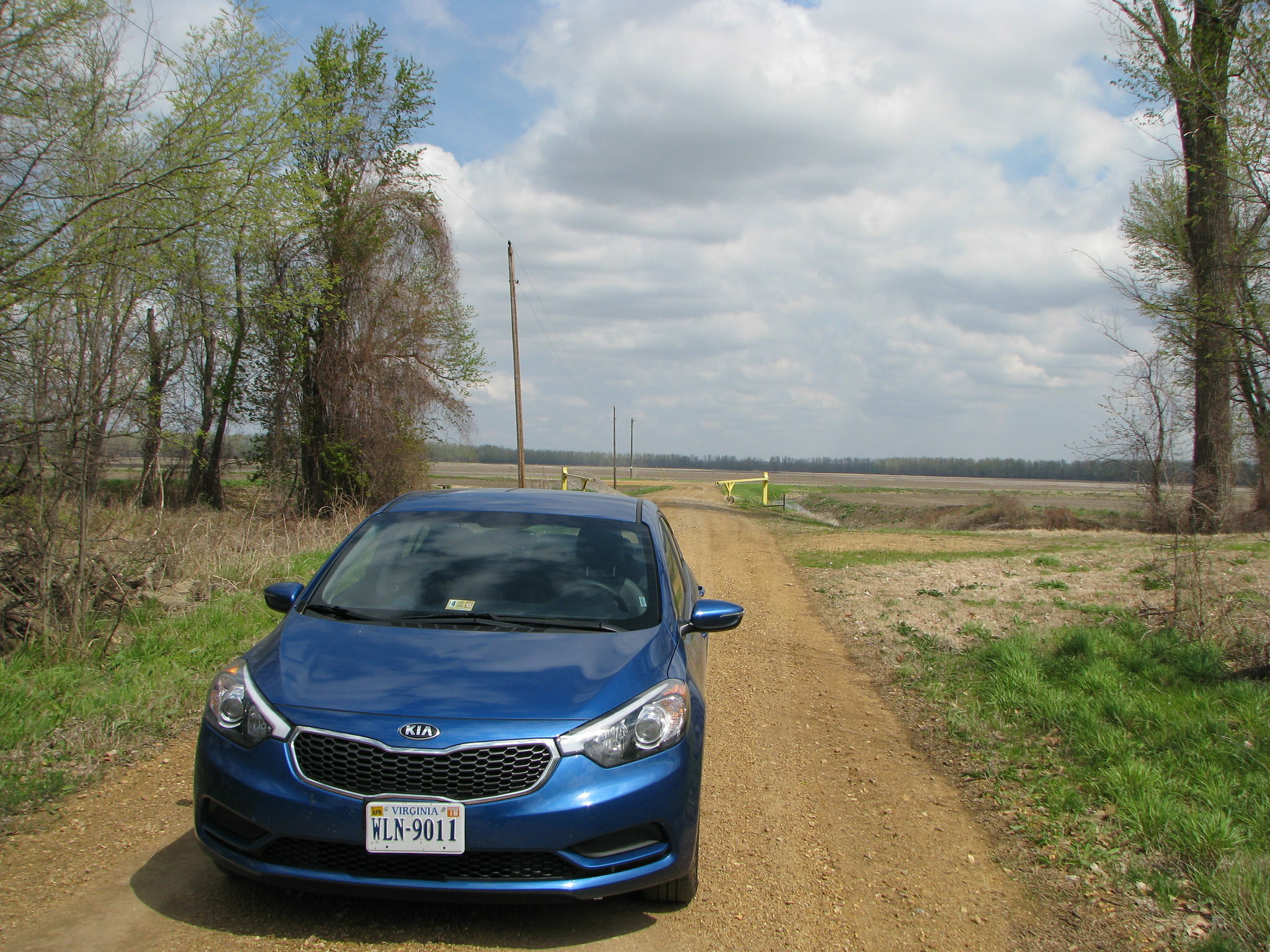
Nonetheless, it appears that there is at least one legal land crossing from Kentucky to Missouri. I'm not the only one to discover this. Here's what the crossing looked like in April 2014, courtesy of the Howder Family:
Tom and I are considering reserving this crossing to complete together as our last objective for our respective border quests. It seems like the most memorable one to finish on.
I can't wait to mark it off!
Some other state border oddities
There are three other state borders that you can't cross in a vehicle: Illinois/Michigan, Michigan/Minnesota, and New York/Rhode Island.
The New York/Rhode Island one is especially interesting to me, as I hadn't ever considered that Connecticut doesn't share a border with international waters. But because of New York's claims to Long Island and Fishers Island, and Rhode Island's claim to Fort Mansfield, Connecticut only gets roughly half of the Long Island Sound. If you would have asked me if Connecticut was bordered on all sides by other states, I would not have answered yes. It seems like a great pub trivia question: "How many of the original 13 states are bordered on all sides by another state?"
This was also surprising to me: the Delaware/New Jersey border features only a single bridge crossing—the Delaware Memorial Bridge that services I-295. Ok fine, it's technically two one-way bridges, but the broader point stands.
However, due to an accident of history, there are now two Delaware exclaves on the wrong side of the Delaware River. This isn't a case of a river changing course though. Instead, it's a result of Delaware's Twelve Mile Circle, the unusual way of defining a state border, and a dredging project. Here's an explanation:
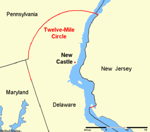
The definition of the northern boundary of the State is unusual. Most of the boundary between the States of Delaware and Pennsylvania was originally defined by an arc extending 12 miles, a.k.a. the Twelve-Mile Circle, from the cupola of the courthouse in the city of New Castle.
This border extends all the way east to the low-tide mark on the New Jersey shore of the Delaware River, then continues south along the shoreline until it again reaches the 12-mile arc in the south. Then the boundary continues in a more conventional way in the middle of the main channel of the river.
For this reason, from the Pennsylvania-Delaware line on south, the border between New Jersey and Delaware is not the middle of the River, but the edge of New Jersey's shore.
Apparently, future dredging projects deposited their loads on the New Jersey side of the river, expanding the landmass there and exceeding the original boundary that was set at the low tide line. The result was Artificial Island, whose tip now extends into Delaware. Similarly, Finns Point also extends beyond the original border line. Neither of these land borders seems to have a road you can use to cross, but it appears you could do so on foot.